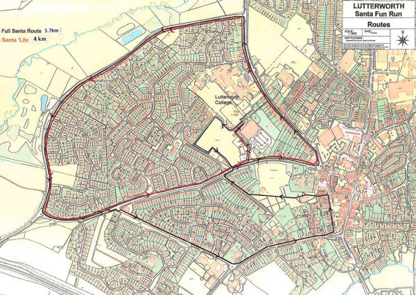
The longer route is 5.7 km, the shorter one is 4 km; both are mainly flat, circular routes around the roads of Lutterworth.
All participants assemble and start at Lutterworth College.
Short Route
- Exit right from the assembly area onto Waterworks Lane, turning left on entering the Recreation Ground. Follow the path by the side of the Sports Centre until you emerge onto Coventry Road. Turn left along Coventry Road until you reach the Wycliffe Memorial. Turn left into Bitteswell Road and continue until you reach Brookfield Way. Turn left along Brookfield Way until you reach Coventry Road. Turn left along Coventry Road until you reach the Sports Centre junction. Turn left and return to Lutterworth College and the finish using the same path you came out on.
Longer Route
- Exit right from the assembly area on to Waterworks Lane, proceeding around the Recreation Ground on to Coventry Road turning left. Go along Coventry Road turning left via the Wycliffe Memorial on to Bitteswell Road.
- Proceed along Bitteswell Road, turning left on to Brookfield Way, down to the end turning left on to Coventry Road.
- Cross Coventry Road at the marshalled point entering Woodway Road, bearing left into Woodmarket.
- Proceed down Woodmarket, turning left into Bank Street.
- At the junction with Churchgate turn left and continue through the churchyard to St Mary’s Road.
- Turn right and follow St Mary’s Road to Coventry Road where you cross at the marshalled crossing point.
- Return to Lutterworth College and the finish via the path along the side of the Sports Centre.
